By Muhammad Luqman
There is a 75-80% chance of an El Niño developing by February 2019, according to latest update from World Meteorological Organization (WMO).
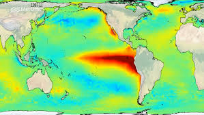
Sea surface temperatures are already at weak El Niño levels in part of the tropical Pacific, although the corresponding atmospheric patterns have not yet materialized.
WMO has also issued a global seasonal climate update, which indicated that precipitation patterns predicted for December-February resemble those normally associated with El Niño. In some regions the precipitation response has been weak, however, or not in keeping with those typically associated with El Niño.
The El Niño/Southern Oscillation (ENSO) is a naturally occurring phenomenon involving fluctuations of ocean surface temperatures in the equatorial Pacific, coupled with changes in the overlying atmospheric circulation. It has a major influence on weather and climate patterns over many parts of the world.
Sea surface temperatures in the east-central tropical Pacific have been at weak El Niño levels since October 2018. However, the atmosphere has not yet responded to this additional warmth, and the upper level winds, cloud and sea level pressure patterns do not yet reflect typical El Niño features.
Model forecasts, according to warning, suggest that this will change within the coming month or two. The chance of a full-fledged El Niño between December 2018 – February 2019 is estimated to be about 75-80%, and about 60% for it to continue through February-April 2019. Model predictions of the strength of the El Niño range from just a warm-neutral condition through to a moderate strength El Niño event, with sea surface temperatures peaking at approximately 0.8 to 1.2 degrees Celsius above average.
The chance for a strong event (sea surface temperatures in the east-central tropical Pacific rising to at least 1.5 degrees Celsius above average) is currently low.
WMO’s global seasonal climate update for December 2018 through February 2019 is based on an ensemble of global prediction models run by WMO-accredited centres around the world. It is currently in a trial phase.
A tilt of the odds towards above-normal surface-air temperature is forecast in most of Asia, Europe, North America, the Caribbean, Africa, Australia, the Indonesian archipelago, and South America. Exceptions include portions of mainly southern South America, much of southeastern North America, parts of northwestern Europe and part of south-central Asia. Most of the regions with above-normal tendencies also saw above-normal temperatures during August-October 2018.
An enhanced probability of below-normal precipitation is predicted in the Caribbean, central America, part of northern South America, the offshore islands of southeast Asia, the southern part of the Indonesian archipelago, some south Pacific islands, portions of southwest Africa and eastern equatorial Africa, subtropical southwest coastal South America and southern South America.
Above-normal precipitation is favoured in part of southern North America, part of southeast South America, part of northwest North America, central and northern Asia, part of southwest Asia, part of the eastern Maritime Continent, and part of Europe. Near-normal precipitation is favoured in parts of interior northern tropical Africa.
.


